Old roads fascinate me. I find the visual evidence of our forebearers' passing mysterious, particularly if the path is no longer in use.
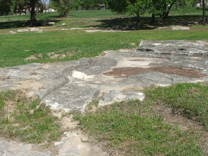 |
| Wagon tracks carved into rocks along old Chisholm Trail near Brushy Creek, Texas. |
The oldest cattle trails of the American West began in Texas, traveled through Indian Territory (later Oklahoma) and ended in Missouri. Later trails, such as the Chisholm Trail, became popular after the Civil War, and traveled more westerly routes to Kansas.
 | ||
| Wagon ruts along old Chisholm Trail near Brush Creek, Texas. |
The Old Shawnee Trail has had many names since the first droves meandered northeast on it in the 1830s. Because it passed near a Shawnee village, that name stuck. Branching off from it are other trails, including the lesser known West Shawnee Trail. While fairly well-known in Texas due to the efforts of preservationists and local historians, not much is known about the route in Oklahoma. Certainly it is unmarked, and seems to be relegated to brief passages in old history books.

I became interested in this particular trail because it travels through Lincoln County, Oklahoma, where my father owns a ranch. I wanted to see if anything remains to the present day near the place where it passes only 13 miles away from Dad's place: Stroud, OK.
As is usual for me, I studied some old maps first. According to the late 19th century sources (admittedly out-of-date for this early 19th century trail), it passed over the Deep Fork of the Canadian River around the Sac and Fox Agency in Indian Territory.

I noticed that even though the trail was largely out of use by cattle in the 1880s, the trails are still marked on the maps.

 |
1932 USGS Stroud, OK Map features red and white “well traveled road” heading North across Deep Fork River |
This "well traveled road" followed more or less the same path as the West Shawnee Trail, even crossing the river near the same location. In 1932, that would make the West Shawnee Trail approximately one hundred years old! Still, does the trail exist today? I turned to Google Maps and was only slightly disappointed.
 |
2011 Map of Deep Fork River bend, approximately 4 miles south of Stroud, Oklahoma (Google). “Well traveled road” follows extant streets until meeting the river. |
I added the red dashed line to help those unfamiliar with the area see where the old trail went. The extant streets today stop short of the river on both sides. However, this is a rural area, and the old fords wouldn't be marked on a 2011 Google Map. Fortunately, Bing provides me with an aerial view, though the view in this area hasn't been updated/improved recently.
 | |
| 2011 Bing Map view of Deep Fork River bend approximately 4 miles south of Stroud. View highlighted of probable crossing of one branch of the West Shawnee Cattle Trail. Looks like the trail is still there! (Thanks, Justin, for the suggestion of Bing.) |
I have yet to actually travel to this area to take some photographs, but probably will within the next few months. I'll be looking for any wagon ruts or depressions in this area indicating the exact path of travel. While the red box marks the "well traveled road" seen in the 1932 map, I must point out that rivers are always altering course, and the cattle probably forded the river at several different locations along this bend through the years, depending upon the season/currents/shifting banks. Spots to the east of the red box are also highly likely locations of crossing.
I queried a prominent Amerindian historian in our area (my mother-in-law), Dr. Mary Jane Warde, and she checked with her Osage friends before emailing back:
"Another friend, Louis Burns, discusses it in his History of the Osage People. He is 91, a sweetheart and an Osage elder who grew up cowboying in Osage County and went on to be a geography professor. He and one of his grandfathers traveled the old Osage trails in a Model T noting the routes and camping places, what the names are and why. He says the West Shawnee Trail followed an old Osage trail, and you can usually trace their routes because they always went along the valleys on the left hand side of a creek or river with the current at your back."
This looks incredible and I look forward to future adventures on abandoned cattle trails. Legend has it, that if you listen close on a moonless night, you can sometimes hear them moo.
ReplyDeleteDear to my heart, and timely. I love what Mann did in 1491 by giving us an understanding of a populated, active pre-Columbian America.
ReplyDeleteI've been talking with locals about "the old road to Wahsatch," referred to by Wilford Woodruff in his journals from the 1870s, especially in one story in which he navigated the road during a terrible storm which arose when he was three miles south of the town now bearing his surname. (I also happen to live three miles south of Woodruff, but his road would almost certainly have been off to the east a little.) WW was a Mormon polygamist leader who used to hide out from the feds in my neck of the woods and wrote about the road from modern Rich County to Wahsatch in Echo Canyon (the eventual popular way to the Salt Lake Valley). I've chatted with people who now own the land upon which the old road would have gone, and have plans to try to find it and reconstruct it via GPS points.
If you do a blog on it, I promise I'll read it. You mention that his late 19th century writings refer to the road as "old" already - do you know how old it is? Was it made by some of the first pioneers? A buffalo trace? A local tribe? I'm very interested.
ReplyDeleteI thoroughly enjoyed Mann's book; the year it came out, I'm fairly certain I demanded that as a Christmas present from my parents, and then proceeded to cite for grad school papers. I could have used a little more focus on North America's networks, but I realize that's very geocentric of me, and far more is known about the expansive South American and Meso American civilizations.
Bing Maps actually has a much better aerial of the area. It actually looks like you can see a trail through the forest to me that could indicate a path:
ReplyDeletehttp://www.bing.com/maps/?v=2&cp=35.69403995835602%7E-96.64238713142462&lvl=16&dir=0&sty=h&where1=Stroud%2C+OK&form=LMLTCC
Thanks so much for suggesting Bing. My post has been updated (and improved).
ReplyDeleteCame here from Emily Post. I will be back... often. :)
ReplyDeleteI am interested in your research, however I am more interested in the East Shawnee Trail. I live in Sedalia, MO and we(a local group) are trying to prove that indeed cattle were driven to Sedalia along this trail from Texas. There are accounts of a large herd 250,00 cattle coming here in 1866. However local historians are trying to disprove that. Do you have information that may help us out.
ReplyDeleteThank you
Linda
Linda, The NPS has opened for comments on this issue. Only about 55 days left to let them hear your views. I'm with you. I live on the Shawnee Trail in Texas and they are doing away with it!
DeleteAre those wagon ruts in rock? Did the rock form after the ruts or was it from use?
ReplyDelete